Sunday, March 6, 2011

Winter Backpacking
2/19/11 - 2/21/11

So I have never done any backpacking before. Up to this point I had only done car camping. Last spring when I started volunteering for Habitat for Humanity I was paired up with another long time volunteer named Rob. We started talking and he found out I hiked year round. He told me about his winter camping adventures and how I should join him and his friend, Bruce, come winter. Over the course of the summer Rob convinced our Habitat Project Manager, Lindsey, and me to take on the challenge of a backpacking trip into the White Mountains. Nothing like diving head first into backpacking.

As with many of my hikes this one started in Waterville Valley. Last year the men had camped out on Scaur Ridge right next to the Tripyramids and felt that would be a great place to set up camp again. While I have done the Tripyramids already in the summer I was holding out hope of being able to get on the North Slide of North Tri in the winter. Another reason Lindsey and I readily agreed on this spot was that my parents were going to be at the condo in Waterville and if we needed to bail out we had a place to stay. We started our trek up Livermore Rd. a little before 9am. If you haven’t ever been here the trail is a former logging road. In fact the bridges still have signs on them for truck weight limits. It is wide, gradual uphill, and becomes a cross country skiing super highway. We beat the groomers and xc rush hour so it was a pleasant hike. Well, except for the 40lb packing I was carrying. My father escorted us to the Scaur Ridge Trail where he wished us luck and sent us on our way. The Scaur Ridge Trail gave us excellent views of the North Slide. I don’t know if I can really describe the sheer joy of finally getting to Scaur Ridge and finding our campsite. My shoulders thank me immensely for removing my bag.

This joy was short lived though. It was time to gather firewood, dig a fire pit, and build two quinzees. I was assigned Paul Bunyan tasks first. While I was Sven Sawing dead trees my three companions were piling up snow for the qunizees. Once we had our two piles it was time to dig the fire pit and get a fire going so we could have some hot beverages. My hot chocolate really hit the spot. That was a good thing because we still needed to go and dig out our quinzees. Due to the fact that Lindsey and I have never built a quinzee before we were split up. Lindsey and Bruce worked on the girl’s quinzee and Rob and I did the guys. Rob started the initial digging but quickly let me go in. At almost 5’10 I was the shorter of the two. I felt like a little kid building the ultimate snow fort. I had always wanted to build an igloo when I was younger and now I was getting a snow cave to sleep in. I would carve chunks of snow out, push them down to my feet, and then kick them out to Rob who would shovel it away. When it came time for the finer details I had to switch and let Rob in. It was probably a good thing because I don’t know if I could have leveled out the floor. I would hate for one of the guys to slide out of the tunnel entrance in the middle of the night. With our homes made it was time to settle into our fire pit for some camp food and lots more hot chocolate. Our fire pit featured a snow bench around the whole fire (except for the ramp leading in and out). The guys had fastened some wire to a tree branch that then hung over the fire. Here was our pot was for melting snow. Having a hot fire and hot food was just what we needed as temperatures dropped to 0 degrees. Lindsey and I started to get cranky after our long day so we headed off to our quinzee around 7:30pm.

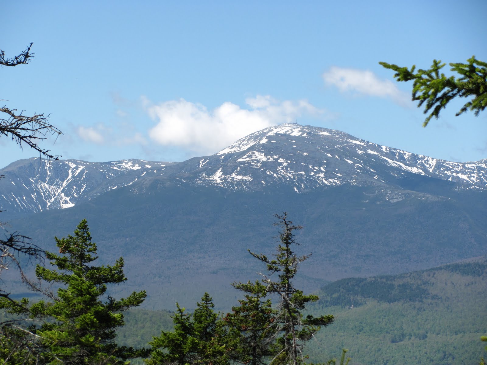
Note to self, change your socks and sock liners before bed and wear more clothes. Ok, I slept pretty terrible my first night. I was cold, my shoulders hurt too much to lie on either side, and I really needed to eat more food before bed. I woke up tired but with a positive attitude about the day. We had some oatmeal to get us going followed up by delicious cheese and bacon sandwiches cooked by Bruce. (For the record I was the one carrying the frying pan in my pack but man was that weight well worth it.) This really perked up Lindsey and my spirits. We all agreed a hike up the Pine Bend Trail to North Tripyramid would be our adventure for the day. The trail can get rather steep and a bit icy. Lindsey and I had our MSR Lightening Axis snowshoes on which were making the guys jealous. Not only did we have better traction then them, but we also had televators. When we got to the summit I wanted to go see the North Slide so we started heading down to it. It didn’t take long before I was sent on to see it and take pictures on my own. The trail was not packed out and again steep. When I returned the guys decided to head back to camp and let Lindsey and I go to Middle Tripyramid on our own. Middle Tri offered a beautiful view into Waterville. It was a nice little spot to sit and have some snacks before heading back. The trip down Pine Bend was a ton of fun. Lindsey got to do her first glissading and loved it. It is so much easier and quicker to go down a mountain that way. When we got back to camp Lindsey and I decided to take pictures of the teddy bear I brought doing different things. I guess this is the 2nd grade teacher in me. He chased me up a tree, pretended to cut down a tree, took a nap, and jumped over our fire pit among other things. All that playing around got me hungry. Tonight we feasted on a four course meal. It started with Cheetos followed up by tomato soup. Next were two different types of mashed potatoes with corn. Our final course of the evening was s’mores. I loved this meal. To me, it was perfect. Following dinner I broke out my Nite Ize Flashlight Frisbee for some headlamp Frisbee. Afterward we helped clean up and retired to the quinzee. Sleep came much easier tonight.

Waking up with light seeping in through our tunnel was almost surreal. Did I really just spend the night in a snow cave at 3000 feet? We wanted to savor our quinzee experience so Lindsey and I stayed tucked into our sleeping bags just chatting for a while. Eventually we had to accept the day and get going. After breakfast we packed up our bags and decided to test the strength of our qunizees. Lindsey went on top of the one she built and I went on the one I built. We also decided to jump up and down and it still withstood our efforts. Finally, we cut holes in to see just how thick our walls were. Turns out Lindsey could have made our quinzee a foot bigger. The four of us took a quick walk up to Scaur Peak before donning our packs for the trek home. Dad met us at the end of Scaur Ridge Trail to escort us back down Livermore Rd. and get pictures of our victorious return.

Note: 4 days after returning from our trip we got word that Rob’s wife was diagnosed with an inoperable brain tumor. Please keep Rob, his wife Bobbie, and the rest of their family in your thoughts and prayers.

Thursday, February 3, 2011

Carter Dome

Ok, so I have been super bad and haven't updated this since May. So I will have to do some back tracking and add in what has been done. In the mean time, without further ado here is the latest installment


#39 Carter Dome
1/22/11
What better way to bond with your father then to go on a hike? Our bonding started only about 3.5 years ago with a recreational snowshoe trip up Snows Mtn. in Waterville Valley, NH. Man did we think we were hot stuff going up a mountain, all 500 feet of elevation gain. It didn’t take long before that wasn’t enough for us. While searching for more trails in the area dad came across a website about the New Hampshire 4000footers. Six months later, on June 1, 2008 we conquered our first NH 4ker, Mt. Tecumseh. We were hooked. Although the views from the summit were limited it still felt so amazing. When could we get up to New Hampshire again to do the next mountain?

Flash forward to now and here we are doing our 39th NH 4ker. For the record we are also on our third pair of snowshoes each. This trips destination was Carter Dome (elevation 4,832ft). Joining us on the hike would be my friend Erica. She did South and Middle Carter with us over Labor Day weekend but this would be her first winter 4ker. Usually I let dad pick what mountain we do and the trails we take. After reading trip reports from others he decided on going Nineteen Mile Brook Trail to Carter Dome Trail to Zeta Pass to Carter-Moriah Trail. I wanted to stop by the Carter Notch Hut, so as we hiked I worked on convincing him to make a little loop out of it.

We got to the parking lot around 8:30am and it was packed. We ended up getting the last parking space. Nineteen Mile Brook Trail was well packed out with everyone going to the hut. Our traction of choice at first was Yaktrax Pros and none of us had any difficulty. We met some people coming back from a night at the hut and I asked if any of them had been to the summit and knew how the trail was from the hut. Unfortunately none of them had been up so dad wasn’t totally convinced yet. We got to the junction of Carter Dome Trail and it was evident that snowshoes would be necessary and that we would be breaking trail. This caused our pace to slow down considerably but we plowed on. I led first. After a while Erica offered to lead and I decided that since she runs half-marathons that she would be perfectly fine in the front. It wasn’t until a little before Zeta Pass that we can across some guys coming down. Thank goodness, they had broken some trail for us. At Zeta Pass we met a lady hiking by herself. She said that we would really enjoy going down to the hut. As she was going up to the summit there were people glissading down the trail back toward the hut. Dad and I love glissading so finally he agreed to make a little loop. Along the way we had seen some glimpses of the presidential range but no good open shots. Finally, along the Carter Dome Trail, we got some openings with beautiful shots. The sky was perfect. Right before the summit we got our best view. It was as if we were living in a postcard. The tiredness of hiking up melts away and is replaced with amazement and joy. Being able to see Mt. Washington without a cloud around it is awesome. The true summit is surrounded by trees so there is no great open view. Since there was a few feet of snow on the ground we were able to find another little opening to get some pictures.

I love gravity. It is great in the winter when you can slide down the trail whether in your snowshoes, boots, or on your butt. We went almost a mile down the Carter-Moriah Trail before it was time to glissade. It was very obvious when that time had come. The trail got very steep. Snowshoes off and time to sit down and enjoy the ride. I used the heels of my boots if I needed to slow down. Along the way I came across a sleeping pad and EMS Nalgene bottle that someone had lost. I picked them up and put them on my lap for the ride. Dad also found a water bottle.When the sliding was done we were almost at the hut. Erica and I went ahead and brought our found goods in to see if anyone there had lost them. Sure enough when we were waiting for dad to show up a man asked if we had seen a Nalgene. We told him it was inside along with a sleeping pad. He was very happy to have his lost items back. The sun had gone behind the mountains so we couldn’t linger long. After a brief rest it was time to get to the car. There was a short uphill right after the Carter Lakes but otherwise the Nineteen Mile Brook Trail was great going down. Dad put his snowshoes on, Erica had her Yaktrax on, and I went bare boot. The trip back was fast and uneventful. It was a long day having to break some trail, but the views more than made up for it.


Tuesday, May 18, 2010

Moriah


#28 Moriah
5/16/10

I forgot my boots! Really who does that? You’re going to New Hampshire to hike and you forget your boots. You know there is going to be snow so your Gore-Tex boots are important. Urg. I was not pleased when I opened the trunk and realized this. Luckily I was wearing my North Face trail sneakers. They would have to be my footwear.

So the Carter-Moriah trailhead was at the end of a neighborhood. It was kind of strange. No parking lot. We were able to park right there though. Turns out we were the only ones on the trail that day. Off we went. Uphill right away. Lucky for me the trail was dry to start off with. I knew this wouldn’t last though. The beginning of the trail was not that interesting. Some uphill, some flats. After a little while we reached the first of a bunch of rock slabs to walk up. I can imagine these would be difficult if wet or icy. Some of them even opened up for some nice views toward the presidentials. Then the snow started. We were at about 2800ft. At first it wasn’t a problem, there wasn’t that much of it. With the snow came some mud though. I was trying to avoid some mud and stepped on some snow. Soft snow. Down my foot went, into the muddy water. I could feel the wetness through my socks. So it begins. Soon enough there was no avoiding snow. It covered everything. Since it was warm out the snow was also soft in spots. That meant post holing. I’m not really sure my gaiters really made a difference. I could tell my feet were wet but at least they weren’t cold. Then the kicker. We got off trail again. Two hikes in a row. There was a ton of blow downs, which made it difficult to follow the trail. I have to admit I was frustrated. Last thing I wanted with wet feet was having the hike take longer. Good thing for dad’s GPS. We were able to figure out where approximately the trail should be and went that way. Eventually we did find the trail again. It wasn’t too long after that before we made it to the top.

It was rather windy and chilly at the top. That didn’t stop me from sitting there and eating some lunch. There is a nice large rock at the summit, which was free of snow. Another groups of three hikers from Montreal came up right after us and we all had plenty of room to sit on the rock and enjoy the 360degree view. Now my feet were getting cold. When I was moving they were good but once I stopped and the wind was getting to them it wasn’t as good. We took a little break and then headed down. Back in the snow. Dad put on Yak-Trax but I decided to just slip and slide my way down. Following the trail was a little easier this way. We did have to refer to the GPS twice but we made it. I was going at a rather fast pace. I was ready to be done with this hike. I probably would have felt different had I had dry feet, but that is my own fault. Going back down was fine, I slipped a few times but otherwise uneventful.


Wednesday, March 17, 2010

The Hancocks

#26 North and #27 South Hancock
March 13, 2010

The lack of snow in Waterville made me a little nervous. I had read there were some stream crossings and I didn’t know if they were exposed. My fears went to the wayside as we drove up the Kancamagus Highway and the snow on in the woods increased. We parked at the hairpin turn, loaded up and headed out.
We both decided to use Yaktrax for some traction. The trail, although not marked was easy to follow at first. At one point though it seemed that most footsteps lead out to the stream. Being that things were not well marked we decided to follow the path most traveled and headed out walking on the stream. Now we knew this wasn’t the Hancock Notch Trail but we had no idea where it really was. We followed along and at one point our path seemed to take a left hand turn. Dad got concerned and checked the GPS. He thought we should go straight but I reminded him that we wanted the Cedar Brook Trail after a while and not the Notch Trail. So we decided to continue to follow the footsteps and go left. Eventually our alternative trail lead us back to the real Cedar Brook Trail. It wasn’t too long before we met up with the Hancock Loop Trail. This was actually fairly well marked. A pleasant surprise that only really lasted until we got to the junction of going to North or South. We picked north, and that’s when the real fun began.
Again we followed people’s footsteps. We dropped down only to have to go up, big time. The footsteps lead us over to the slide. Umm, not the trail, but we couldn’t figure out where the real trail was. We decided that last time the footsteps got us where we needed to be so why not follow them again. Up the slide we went. For the most part it was like climbing stairs, I found a foot hole and used it. This was kind of nice, less stress on the calves. The higher we went the harder it was to figure out where all the footsteps went. I spotted a cairn and decided to go toward that. Things were now getting icy and I was starting to wish I had my crampons on and my ice axe with me. Dad was on all fours at this point. We took a break at the cairn and then kept up with the footprints. They lead us finally back into the woods, but again it didn’t look like on to a trail. At some point I lost the footprints and we were on our own, so we just kept going up. Somehow we managed to find the real trail right before the summit. We got to the top and took some pictures. The summit offered some nice views back to the south. Next stop South. Off we went.
This time the trail was easy to follow. The yellow blazes were obvious. This was a welcomed treated. The trail between the two peaks was not too bad and occasionally offered some views of Franconia Ridge and North, including the lovely slide we climbed up. The summit of South on the other hand had no views. So we didn’t really hang around there long. As we were going along I slipped and fell on my bottom and started to slide down the trail. Why get up? So I continued to slide down. Dad decided to give me some room and slide down also. We managed to cover almost 600 vertical feet very quickly. Actually it was a lot of fun and made the trip down easier on the body. Eventually we had to get back up and walk but it wasn’t long before we made it back to the junction. From there we just headed back how we came. After we got off the stream this time someone had put an arrow in the snow pointing the way you were suppose to go. Oh well. We made it in the end.

Monday, January 18, 2010

Mt Madison

#25 Mt. Madison
January 16, 2010

So I had been checking weather.com all week for the forecast on Mt. Washington. Turns out I should have checked the high peaks forecast at mountwashington.org instead like dad did. More on that later. So the forecast was looking good and dad and I both wanted to hike up Mt. Madison. I really wanted to use my crampons and get a good winter climb in. Temperatures were looking good and so was the wind (so I thought). We left Waterville at our usual 7am start. We parked at Appalachia just like we had 6monthes earlier when we did Adams. This time our trail of choice was Valley Way.

At the trailhead there was a group of guys preparing to head out, we said our hellos and went long. Valley Way is a nice trail. It is well traveled so it is packed down. Once again I took snowshoes and didn’t need them. I have to keep telling myself the extra weight is good exercise. The beginning of Valley Way is a gentle uphill. You don’t get any really steep sections in the first mile and a half. Even then it isn’t bad until about a half mile to the hut. Dad and I wore our Yaktrax on the way up. We were surprised that the group of guys didn’t pass us. With about a mile to go we encountered another group of guys. This group was coming down. They had hoped to do a Presidential Traverse but the weather was too much and turned them around. So I am thinking, great, this can’t be good. A little farther along we encountered two more guys. They had wanted to do Madison but turned back because it was “socked in.” Even more lovely news. Although, they did say they had talked to a group of 4 that had been successful. Along we continued and soon we met the group of 4. We chatted awhile and they said they could see cairn to cairn so they made it. Alright, some positive news, kinda. We were in the clouds at that point and I hate not having any views. Plus you could hear the wind getting louder. I was starting to doubt weather.com’s forecast of 30mph winds.

Finally we made it to the Madison Spring hut. Here we encountered two guys that had just come off Adams and said it was wicked up there and no views. We were pretty much still in the clouds. Not wanting to give up we found the side of the hut that was most protected and put our crampons on. Suddenly Madison came out of the clouds. It was time for us to head up while there was some sun. We dropped our bags around the corner, under the hut and headed up the summit cone. Now at this point I was well aware that the winds were much stronger then 30mph. I found myself at times running up the slope. I wasn’t doing this because I was excited, I was doing it because there was a serious tailwind pushing me. The higher we went the winder it got. I started having difficulty with balance. The rocks became my friends as they offered balance and a little wind block. Soon I felt like I was in a cartoon, leaning full tilt forward, not going anywhere and not falling. Then a slight let down in the wind and I moved on. Then I got blown to the side, up and at it again. Finally I could see the summit. There she was. There also was a 15foot section that had no rocks protecting it and near hurricane strength winds blowing. I sat down and waved dad on. I was afraid to go. I didn’t want to be blown off.

As I sat there talking to myself I realized I couldn’t come this far and not go on. I was less then 100ft from the summit. There was a slight let up again and this time I ran not because of the wind pushing me forward but for fear of it pushing me over. I ran up and dad pointed to a spot for me to sit. There was a tiny bit of protection here. He had to fix his crampon and I tried to take pictures and not lose the camera. Once he fixed the crampon it was time to get off and back to the hut. Off we went. I took off because I wanted out of the wind. I then noticed I was struggling to breath. Here I am walking into 60+mph winds at 5300feet elevation. I turned me head a bit so I could get more air in and out. Luckily this trick worked. As we headed down I saw a group coming up. It was the guys from the parking area. They too had dropped their sacks and were making their way up. I stopped and chatted for a minute and waited for dad. Then I kept going. I was very happy when I saw trees again. See as we were coming off the mountain the clouds were rolling back in. While we were up there we were above them but could see Mt. Washington engulfed in them. Dad came down a little bit after me, turns out his crampon fell off and he went down using one, which caused some falling. We got back down to the hut where I was more then happy to dig into some food. We chatted with some guys taking a lunch break and took a rest. After a little while we gathered our supplies and headed down. The way down was uneventful, but I was very happy to get to the car and our post hike chocolate milk.

Thoughts: AHHHH. That was crazy! I crawled, got blown over, had a hard time breathing but pushed on. My fear of getting blown off was a bit much. I had the ice ax if need be for self arrest and there was no great cliff. I did have to talk myself on but I think that is what sets us apart from those who turn around. I knew to wait for a little let up to move from protection to protection. I had the proper clothing. Some people think I am crazy for what I do but the rush I got being up there is something they will never experience. Oh yeah, I think that is about my limit with the wind. Any higher speeds would be a bit much.

Thursday, December 31, 2009

#24 Mt. Waumbek
12/19/09

I love how the fact that this was two days short of the official start of winter made this a fall hike. It certainly didn’t feel that way. On the drive in the car thermometer showed as low as –11 degrees. At the start it was –6 degrees, the coldest start I have had. There was plenty of snow on the ground but alas I was NOT walking in a winter wonderland.

This time dad and I were not alone. Dave was joining us for the hike. I warned him we weren’t fast hikers and today I really wasn’t. I was starting to get a cold, which caused me to drag my wagon. I also was wearing my plastic boots to get use to them and that slowed me down some. We parked right next to a gas station in an alternative parking lot. The trailhead lot was closed but this only added maybe a half-mile to our round trip. The trail was not difficult. This was good again cause I wasn’t on my A game. At the beginning of the Starr King trail the snow was fairly packed and we weren’t post holing. As we climbed though the snow started becoming more powder and less packed down by others. This caused more post holing. Dad was getting really annoyed. It didn’t bother me too much probably because I am lighter and don’t post hole as much.

When we got to the top of Starr King we took a bit of a lunch break. Dave found a nice rock to sit on and dad and I sat by the random fireplace. We decided that we were going to leave our bags here and go lighter to get to Waumbek. Dad decided to put his snowshoes on but Dave and I stayed in boots. It was a lot better having less weight on your shoulders for the hike over. There were a few little viewpoints but not too much. When we got to the top of Waumbek there wasn’t any view, urg. I plopped down and decided to do a snow angel. We took some pictures and headed back with some speed. See a blizzard was brewing down in NY/NJ and we wanted to get home before it hit CT.

Going down I was doing better. I had some energy from my food and the whole using gravity helped. I was slipping a bunch because of the plastic boot bottom but did well. I was very happy to get back to the car and sit down. Thank goodness this wasn’t a more difficult hike because my body was having a hard time. I kept telling myself “I can do all things” and I made it.

Next up, a “real” winter hike. LOL

Sunday, December 13, 2009

Carrigan #23 for number 23

11/25/09
This is not so much a trip report but a tribute. The Saturday before Thanksgiving during a JV football game Matty B. of Ledyard collapsed on the field of an aneurysm and was rushed to the hospital. Things took a turn for the worse on Sunday and he was transferred to CT Children’s Medical Center. There it was determined that he was brain dead. His parents decided to keep him on life support so friends and family could say their good byes. They also kept him on so that they could donate his organs. A few months before when he got his license he signed up to be an organ donor and his parents granted his wish. The Tuesday before Thanksgiving he was taken off life support and passed away. I headed up to New Hampshire with my parents and uncle right after finding out he had passed. I sat in the back with a heavy heart. Many of my soccer players were friends with him and were devastated on Sunday at a vigil. The gasps you heard when the superintendent said he wasn’t going to make it, the boys crying, it was a hard time. One girl asked me why this had a happen and she expected a response. I told her that he did not suffer and he went out doing something he loved, football. I also told her that in his dying he would save many others. His lungs were to go to a 12 year old.

So here I am going to one of the best views in New Hampshire yet we are completely engulfed in clouds. Off we went. Again I don’t remember much about the hike, I just kept thinking about Matty. His football number was 23 and this was my 23rd 4000footer. What I do remember was a nice ridge before the top, well it seemed like it would be anyway, all I saw was cloud.

The top was very windy and wet.

We stayed for a little while to have a snack and then headed down. My uncle runs marathons so he took off. Soon after I got a surge of energy and took off myself. I just got into this great rhythm and was practically running. Actually, after the last stream crossing I did run to the end. I have never felt that good after a 10mile hike. It was as if I had extra energy. I beat the book time by almost an hour and a half. My uncle had waited for my dad and they came along 20min later.

So Matty B. this hike is for you. One may die so others may live. You are a true hero.
“I can do all things”