Repeating #2 Mt Osceola
June 7, 2009

Dad and I were staying up in Waterville a day longer and we had to decide on a second day of hiking. I suggested Osceola because last year when we went up you could only see 10 feet in front of you. I heard the view was good and I wanted to see it myself. Plus if we had to turn around for some reason we were still in the valley and it wouldn’t be a big deal because we have done it before.
We waited until noon to head out. We wanted to see everyone off who was headed home. The only problem was that the Weather Channel was forecasting a chance of rain for 2:00pm. Now I was a little tired and sore from the day before. I had a blister on my right heel that had a Band-Aid on it, but I was on a mission. Must get to top and see view. So off we went from the parking lot on Tripoli Road. It was fairly rocky from what I had remembered. If you have some balance this is pretty easy to deal with, only slows you down a little bit. It does take well over a mile though for things to smooth out. We took our regular first hour stop but this was just a short rest and some liquids. We had lasagna for lunch at 11:30 so neither of us needed food yet. We powered our way up. Occasionally, through the trees, you could catch glimpses of Mt. Tecumseh. Then I could see the dark clouds brewing in the west. This caused my pace to maintain, if not increase slightly. Must, see, view. Now I never would have thought that I could go at that pace the day after doing 11miles over 2 4kers. Mind over matter.
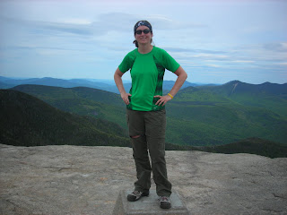
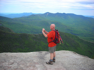
We got to the top and it was well worth it. Way different from the last time. The views swept from Mt. Washington, down to yesterdays peaks, the lakes behind them, and over to Tecumseh. Man I have got to come back here in a crystal clear day with a picnic lunch.
This is the perfect place. Great views, nice flat rocks to sit on. I took some pictures and a video, had some snacks, and talked to some other hikers. Dad already left in search of the other views. I felt some rain drops, put the raincoat on, and headed back a little bit. Right before the top there was a big rock with some concrete footings on it. This is where the side trail is to the views on the other side. Although this viewing rock was smaller it gave the rest of the views we didn’t see before, including Franconia Notch and back to the presidentials. While this isn’t a true unobstructed 360 degree views between the two places you can see 360 degrees.

The clouds weren’t looking promising and we didn’t want to get really wet so we headed down, again at a fairly rapid pace. There are some rock slabs to walk across and we didn’t want to see if they become slippery when wet. At this point I can tell my Band-Aid has fallen off and my blister is not feeling so well. The hot spots on my big toes are also becoming really hot. That didn’t stop me though. I wanted down. I didn’t want to get wet and I did want to get to Lahout’s in Lincoln before it closed for the night. On our way down we discussed how we would most likely be coming back here more. It is a fairly easy 4ker. Only gaining 2100 feet with a bunch of switchbacks to make it very manageable. Plus the view at the top is great. I will have my picnic lunch of here one day.

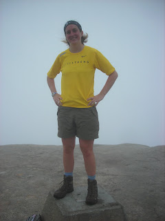
Thoughts: I would recommend this as a first 4ker. As long as you have some balance the rocks are not difficult. Even if you aren’t interested in 4kers this is still a great hike with a beautiful reward at the top. Bring a picnic lunch in your backpack and enjoy your stay at the top. You won’t be disappointed, unless of course the top is in the clouds and you can only see 10 feet in front of you.


