Panorama Point, Mt. Rainier July 19, 2009

We got down to Mt. Rainier National Park right after the sunset and headed to Cougar Rock Campground. Upon arriving we saw the full sign but decided to check out if it really was full. In fact every place had someone in it or a reserved sign. We tried to reserve but it wouldn’t let us (must have been filled already). We decided to ask the camp hosts just in case. They confirmed our fears, it was 110% and the next closest campground was about 30miles back where we came from. Dejected we made the loop around to leave only to be stopped by the host standing in the middle of the road. Her husband just informed her that two sites had just opened up because the people staying there got sick. Excited, we followed the husband over to pick our site. Setting up camp was fun at 10pm with headlamps. Ok, I admit it; I used a redneck hat that was camouflage with lights in the brim instead of my headlamp. Once we got settled it was off to bed. The only problem was a new group was coming in tomorrow so we would have to try to move again. So right after breakfast Saturday morning Scott headed out with Natalie (using a 18month old for sympathy) to find us a new spot. I suggested Amy, being almost 8 months pregnant, go with Natalie but Scott was successful. We threw everything in and on the Xterra and headed to our next home. Due to all this moving we decided to wait until Sunday for our hike. This was a good choice because Saturday was a zoo being a National Park Fee Free Weekend. I will do everything possible not to go to another park on a fee free weekend again. Just pay the entry fee. Of course we had no choice, this is when I was out there. We decided to get up Sunday at 6am and head out to hopefully beat the masses if they came out again.
We had no problem finding a parking spot at Paradise. Our initial plan was to go to Paradise Glacier so we headed out on the Skyline Trail in the counterclockwise direction. The beginning of the trail is paved for all the tourists.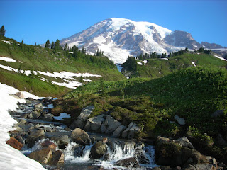 Soon enough we were on a path. Pretty soon the path lead to snow. I had my Yaktrax with me so I decided to put them on after slipping around a little. Scott didn’t have any but was very happy he decided to bring his friends poles. The first real time on snow was up a short but steeper section. I believe when we got to the top we were on Mazama Ridge.
  There was more snow then dirt ground at this point but the trail was easy to follow since there were little markers poking out. At one point we heard a noise and tried to figure out what it was. Turns out it was a ptarmigan. I was a bit disappointed it wasn’t something bigger. The view was fabulous along the ridge.
  You could see up to Rainier or down into a valley and were surrounded by peaks all around. When we got to the Stevens/Van Trump Memorial we decided to head toward Panorama Point instead of Paradise Glacier.
We kept following the Skyline Trail, which was pretty much all snow now. I wish I had known, there was an awesome place to sled. It would have been easy to bring an inner tube along and blow it up when we got there. Due to all the snow we didn’t see as many flowers as expected, I guess we were a little too early. Along the way we did get to see two marmots that were only about 10feet away.
  I now felt a little better about seeing some different animals. (Where are those mountain goats people spotted yesterday?) There were more patches of dirt trail along with snow that was still deeper then me.
  Along the way up we met a skier who had just done a run and was planning his next. Up we went to Panorama Point. From there we could see through the haze and just over the neighboring peaks Mt. St. Helens, Mt. Hood, and Mt. Adams.

Behind us of course looming above was Mt. Rainer. Talk about a tease, we had to turn around and head back. Amy and Natalie were waiting down at the campsite. We headed back down via Golden Gate Trail. As we were heading down we saw the skier making a run down where we were headed.
  We passed two groups of Rainier Mountaineering heading up the trail. I was jealous of them. Their thoughts were on the summit, a place I would like to go. Soon enough we were back to the paved path and encountering the tourists looking for the waterfalls.

We got down to Mt. Rainier National Park right after the sunset and headed to Cougar Rock Campground. Upon arriving we saw the full sign but decided to check out if it really was full. In fact every place had someone in it or a reserved sign. We tried to reserve but it wouldn’t let us (must have been filled already). We decided to ask the camp hosts just in case. They confirmed our fears, it was 110% and the next closest campground was about 30miles back where we came from. Dejected we made the loop around to leave only to be stopped by the host standing in the middle of the road. Her husband just informed her that two sites had just opened up because the people staying there got sick. Excited, we followed the husband over to pick our site. Setting up camp was fun at 10pm with headlamps. Ok, I admit it; I used a redneck hat that was camouflage with lights in the brim instead of my headlamp. Once we got settled it was off to bed. The only problem was a new group was coming in tomorrow so we would have to try to move again. So right after breakfast Saturday morning Scott headed out with Natalie (using a 18month old for sympathy) to find us a new spot. I suggested Amy, being almost 8 months pregnant, go with Natalie but Scott was successful. We threw everything in and on the Xterra and headed to our next home.
 Due to all this moving we decided to wait until Sunday for our hike. This was a good choice because Saturday was a zoo being a National Park Fee Free Weekend. I will do everything possible not to go to another park on a fee free weekend again. Just pay the entry fee. Of course we had no choice, this is when I was out there. We decided to get up Sunday at 6am and head out to hopefully beat the masses if they came out again.
We had no problem finding a parking spot at Paradise. Our initial plan was to go to Paradise Glacier so we headed out on the Skyline Trail in the counterclockwise direction. The beginning of the trail is paved for all the tourists.
 Soon enough we were on a path. Pretty soon the path lead to snow. I had my Yaktrax with me so I decided to put them on after slipping around a little. Scott didn’t have any but was very happy he decided to bring his friends poles. The first real time on snow was up a short but steeper section. I believe when we got to the top we were on Mazama Ridge.
  There was more snow then dirt ground at this point but the trail was easy to follow since there were little markers poking out. At one point we heard a noise and tried to figure out what it was. Turns out it was a ptarmigan. I was a bit disappointed it wasn’t something bigger. The view was fabulous along the ridge.
  You could see up to Rainier or down into a valley and were surrounded by peaks all around. When we got to the Stevens/Van Trump Memorial we decided to head toward Panorama Point instead of Paradise Glacier.
We kept following the Skyline Trail, which was pretty much all snow now. I wish I had known, there was an awesome place to sled. It would have been easy to bring an inner tube along and blow it up when we got there.
 Due to all the snow we didn’t see as many flowers as expected, I guess we were a little too early. Along the way we did get to see two marmots that were only about 10feet away.
  I now felt a little better about seeing some different animals. (Where are those mountain goats people spotted yesterday?) There were more patches of dirt trail along with snow that was still deeper then me.
  Along the way up we met a skier who had just done a run and was planning his next. Up we went to Panorama Point. From there we could see through the haze and just over the neighboring peaks Mt. St. Helens, Mt. Hood, and Mt. Adams.
Behind us of course looming above was Mt. Rainer. Talk about a tease, we had to turn around and head back. Amy and Natalie were waiting down at the campsite. We headed back down via Golden Gate Trail.
 As we were heading down we saw the skier making a run down where we were headed.
  We passed two groups of Rainier Mountaineering heading up the trail. I was jealous of them. Their thoughts were on the summit, a place I would like to go. Soon enough we were back to the paved path and encountering the tourists looking for the waterfalls.
 A fox (picture taken from in a car)
Thoughts: GO BACK! GO HIGHER! Summit!


